Pixxel shows where more of the economic value in commercial space may be created after a satellite reaches orbit. Combining proprietary sensors, recurring Earth data and software allows a space company to sell useful information to industries that may never think of themselves as space customers.
- Pixxel raised $100 million in Series C funding, bringing its total funding to $195 million.
- Its operational Firefly constellation includes six hyperspectral satellites, all launched in 2025.
- Pixxel combines satellite infrastructure with its Aurora software platform to move from raw Earth imagery toward usable analysis.
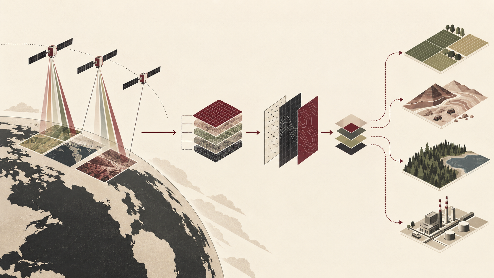
- The model demonstrates a broader space-business chain: sensors → proprietary data → software → decision-ready intelligence.
Pixxel has raised $100 million in Series C funding as it builds a business that stretches far beyond putting satellites into orbit.
The round was led by Singapore state investor Temasek and Seraphim Space Investment Trust, with participation from existing investors Radical Ventures and growX Ventures and new investors including 360 ONE Asset and IMM Investment. The financing brings Pixxel’s total funding to $195 million.
That is a significant amount of capital for a young space company. But the more interesting part of Pixxel’s strategy is what happens after its satellites reach orbit.
The company is building a vertically connected Earth intelligence business: satellites collect specialized imagery, that imagery becomes proprietary data, and software turns the data into information that customers can actually use.
In other words, the satellite is not necessarily the final product. It is the infrastructure that produces the product.
Seeing More Than an Ordinary Image
Pixxel specializes in hyperspectral imaging, a form of Earth observation that captures information across many narrow wavelengths of light.
A conventional photograph mainly tells us what something looks like. Hyperspectral imagery can reveal additional information about the physical or chemical characteristics of what is being observed.
Pixxel’s operational Firefly constellation consists of six satellites. Its current documentation says Firefly captures data across 135 spectral bands in the visible and near-infrared range at roughly 5-meter resolution. All six satellites were launched in 2025.
That additional spectral information can make satellite imagery useful for problems that are difficult to understand from an ordinary picture.
NASA, which has acquired Pixxel datasets through its Commercial Satellite Data Acquisition program, lists applications including agricultural monitoring, water-quality assessment, forest and ecosystem health, mineral exploration, infrastructure surveillance and disaster response.
For a mining company, for example, the value may be information about minerals or environmental conditions. For agriculture, it can be changes in vegetation or crop health. For governments and researchers, the same underlying sensing infrastructure can support environmental monitoring and disaster analysis.
That changes the business question from “Who wants satellite pictures?” to “Who needs information about what is changing on Earth?”
The second market is potentially much broader.
The Business Does Not Stop at the Satellite
Collecting sophisticated imagery creates another problem: customers still need to interpret it.
Pixxel is addressing that layer through Aurora, its Earth observation software platform.
Aurora provides a no-code environment for working with satellite data and includes models and indices designed to make Earth observation analysis easier to use. Pixxel describes the platform as a way to move from raw imagery toward practical insights without requiring every customer to build a remote-sensing operation internally.
That creates an important business mechanism.
Satellite → imagery → proprietary data → analysis software → usable intelligence
The further Pixxel moves along that chain, the less its business resembles a company simply selling access to hardware in orbit.
A satellite is expensive infrastructure. Data can be collected repeatedly. Software can organize and analyze that data for different customers and applications.
Building all three layers therefore gives Pixxel multiple places to create value from the same underlying space infrastructure.
Why $100 Million Matters
The new funding is intended to help Pixxel expand that infrastructure.
According to Reuters, the company plans to develop its next-generation Honeybee satellite constellation and additional high-resolution imaging satellites while expanding Aurora toward more integrated, decision-ready intelligence.
Honeybee is particularly important to that expansion. Pixxel’s technical documentation says the planned constellation will extend observation from visible and near-infrared wavelengths into short-wave infrared, broadening the spectral information its satellites can collect. The company currently lists Honeybee for launch beginning in 2027.
Pixxel is also expanding beyond its own commercial constellation.
Earlier in 2026, a Pixxel-led consortium signed an agreement with India’s space regulator and promoter IN-SPACe to develop a national Earth observation constellation. The consortium plans to invest more than ₹1,200 crore over five years in 12 satellites spanning hyperspectral, multispectral, radar and very-high-resolution optical imaging.
Seraphim Space Investment Trust separately disclosed in August that it was investing another $25 million in Pixxel.
Together, those developments show a company moving from proving that its technology works toward building larger-scale infrastructure around it.
Space Is Becoming a Data Business
Pixxel also illustrates a broader change in the commercial space economy.
The most visible part of the industry is often launch: rockets, launch pads and spacecraft leaving Earth. But once more satellites are in orbit, another economic layer becomes increasingly important.
Satellites can function as data-producing infrastructure.
The business opportunity then moves downstream.
A company can build the sensor. It can operate the satellite. It can own or distribute the resulting dataset. It can build software to analyze that information. And it can ultimately sell an answer to a customer rather than simply selling an image.
Pixxel is trying to connect those layers within one system.
That model also helps explain why Earth observation can reach industries that do not think of themselves as part of the space economy. Agriculture, mining, energy and environmental management may use information generated in orbit without needing to operate satellites themselves.
Space becomes part of the infrastructure behind an ordinary business decision.
From Pictures to Decisions
The next stage for Pixxel will be about scale.
Its six Firefly satellites already provide an operational foundation. Honeybee could expand the kinds of information the company can detect, while Aurora can make that information easier for customers to interpret.
The $100 million Series C gives Pixxel more capital to connect those pieces.
And that is what makes the financing more interesting than another large space funding round.
Pixxel is building satellites, but the larger business it is pursuing is intelligence: owning the infrastructure that observes Earth, producing differentiated data from those observations, and turning that data into information that businesses and governments can use.
The satellite may be where the data begins.
The business is what happens after it comes back down.
The interesting asset in Pixxel’s model is not just the satellite. A satellite creates observations; proprietary data makes those observations commercially differentiated; software makes the data accessible; and useful intelligence gives customers a reason to pay for it. That progression is a useful way to understand the next layer of the space economy: increasingly, the companies worth watching may not simply be those that reach orbit, but those that build businesses on top of what orbit can continuously produce.
- News Reuters — Google-backed Indian space startup raises $100 million in latest funding round, Sept. 7, 2026
- Company research Pixxel — Hyperspectral Imaging for Earth Observation; Firefly constellation and Aurora platform
- Government research NASA Science — CSDA Vendor: Pixxel; commercial hyperspectral data and Earth-science applications
- Company research Pixxel Documentation — Pixxel's Constellation; Firefly and Honeybee technical specifications
- Investor / Official release Seraphim Space — Pixxel-led consortium signs agreement to build India's national Earth Observation constellation, Jan. 26, 2026